The record-breaking wild, wet and windy winter of 2014-15 was probably a game changer for many reasons. The onslaught of storms fired a series of warning shots showing what climate change probably has in store for us. Serious and prolonged flooding, especially in the Somerset Levels, where about 6,500 ha (c.10% of the area) was under water for several months, and along the Thames in Berkshire, revealed a paucity of resilience at all levels. Despite having successfully defended many thousands of properties from flooding this winter, the Environment Agency became the scapegoat, blamed for allowing the flooding to occur because of something it hadn't done, or in some cases, had done (such as creating the Jubilee River which successfully protected Maidenhead from flooding). It received (in my view) an undeserved kicking from many individuals and some politicians for failing to dredge rivers or install sufficient flood defences, when it has been forced by Government to making swingeing cuts, affecting front line staff and capital expenditure. Further cuts of 1550 staff are planned for the coming financial year, although the flooding crisis has put a consultation on this temporarily on hold.
In the Somerset Levels, where the clamour for river-dredging has been particularly loud, it was subsequently revealed that the EA had agreed that some dredging was needed, but didn't have enough money, while local authorities had refused to contribute. Meanwhile, in recent years, the same local authorities have granted planning permission for new houses in areas that were under water for several months. Andrew Gilligan, writing for The Telegraph, reveals that land next to Curry Moor had also been designated by Taunton Deane Borough Council for new homes while "the neighbouring council, Sedgemoor, had identified sites in at least four villages for housing, even though all are within the highest-risk flood zone". Gilligan also describes the scale of projected housebuilding in areas flooded by the Thames. While most would agree that local authority planning policy is as leaky as a sieve, it is driven by national housebuilding targets and the Coalition Government's dogmatic pursuance of economic recovery based on a stripped-down planning system that has little ability to refuse permission for new homes, even if they are going to be under water within months of occupancy. Government has been a clear and guilty accomplice in the scale of damage caused by floods but the insurance industry is now beginning to call the shots. This is hardly surprising, given the estimated £400m of payouts anticipated from damage this winter and warnings from the UK Climate Change Impact Assessment that nearly 1 million properties are likely to be at risk of flooding during the 2020s. There is no doubt that the Government will continue to support building houses in areas of flood risk, such as at Ebbsfleet (North Kent) where it has announced it is to support the development of a new garden city. The area is considered as being at high risk of tidal flooding.
Magicians Paul Daniels' and Debbie Magee's luxury Thames-side home was one of many threatened by the overflowing river (they kept theirs dry by continous pumping), and they too accused the Environment Agency of causing the severe flooding by failing to dredge the river (thus the water would be instantly magicked away, wouldn't it?). Politicans were caught back-footed, with some (including Communities Minister Eric Pickles, and Somerset MP Ian Liddell-Grainger) behaving in ways that were wholly inappropriate to their status. IL-G, who can at best be described as a baying buffoon, said that EA Chairman Chris Smith " is a coward, a little git and I'll flush his head down the loo". The TV satire Spitting Image would have had a field day with the lot of them.
The voices of reason from ecologists, hydrologists, engineers, climate-change scientists, the Government's own independent advisers (including the Emvironment Agency and Natural England) and independent commentators, such as George Monbiot, had, until the latter stages of this event, been drowned out by the vociferous minority interests of farmers, the National Farmers' Union and ill-informed politicians (as well as traumatised flood victims) seemingly incapable of taking in the wider picture and the alternative view. However, evidence (much of it collected thanks to Government-funded research, work by the EA, NE and a few water companies) shows that river-dredging and hard defences are out-dated and expensive one-trick ponies that will often not work and in some cases make things worse. For these reasons, engineers and ecologists agree their use should be limited and targeted in places where sufficient evidence is able to show clear cost-benefit. (More on this via G Monbiot here.)
The scale of the damage, from farmland and houses underwater for three months, to the destruction (yet again) of the main coast rail line at Dawlish, and disappearing houses at Hemsby, show that choices will need to be made. There is not going to be enough cash to defend every vulnerable house, industrial estate, field or farm from the floods, or every crumbling coast from rising sea levels and increasing storm surges. As part of catchment-based flood mitigation plans, and as now indicated in the emerging action plan for the Somerset Levels, water will need to be held back upstream, using ecological restoration techniques and by reversing some of the inappropriate land drainage that causes silt and nutrient-laden soil to devastate land and settlements downstream. This is where the winter storms have become a game changer - upstream measures now have a credible place at the table, helped by the mounting evidence of benefit and greater media coverage given to environmental scientists who can describe what is needed, and warn against what may be unaffordable and unachievable.
On 5 March, a clear reality check was offered to the Government by Professor Sir John Krebs. Writing to Environment Minister Owen Patterson on behalf of the Adaptation Sub Committee of the UK Climate Change Committee, Sir John offered five key points to consider in relation to Somerset Levels action plan: (1) the plan needs to recognise rising sea levels and flood risk associated with climate change; (2) it should consider the range of drivers operating on the Levels; (3) the plan should be sustainable and cost-effective; (4) it should focus on adaptation and be responsive to new evidence; (5) responsibility for delivering and funding the plan should be shared. In the letter, Sir John makes pointed comments about exploitation of Level's peatlands (which have shrunk as a result and further lowered land levels), the appropriateness of farm subsidies and the need for a review of land-use practices in the catchment. In an interview with The Times (reported in The Western Daily Press) Lord Krebs more explicitly suggested that "It may well be the case that there are areas too expensive to defend". Needless to say, his honesty was not welcomed by either Somerset farmers nor the local MP.
This was preceded, in February, by a letter written to The Telegraph by seventeen professional bodies, representing engineers, ecologists, hydrologists, surveyors, landscape architects, foresters, arboriculturists and other environmental scientists, calling on the Government to act on knowledge and best practice, and have a joined-up strategy for managing water, to include soft-engineering solutions. Growing experience in such techniques, such as piloted in Exmoor and at Pontbren, shows that farming and ecological restoration are not mutually exclusive, although there will certainly need to be a major rethink about intensive farming practices that are causing soil erosion and unacceptable levels of runoff. The dialogue about what to do about this in England has come in the nick of time, as Natural England is putting together proposals for the new environmental land management scheme paid for out of Pillar 2 of the Common Agricultural Policy. This scheme, and a much more comprehensive approach to Catchment Sensitive Farming, could offer the 'carrots' but the stick of regulation will still be needed, coupled with much better monitoring and enforcement of basic environmental protection measures that will act to dissuade farmers from causing significant damage to land and rivers. There is plenty of evidence showing that neither carrots or sticks are working across much of the countryside right now, not helped by the Coalition Government's wish to strip down regulation, cut back regulatory agencies and let everyone police themselves. In the future farm subsidy cash (up to £200 per hectare) must come with an absolute requirement that those in receipt of it practice sustainable land use. This requirement however, will not be met unless there is a comprehensive extension programme in place with one-to-one advice available, and support for the production of farm- and operations-based environmental improvement plans that farmers and their contractors will need to sign up to.
Back along the coast, the National Trust has already begun to face up to the fact that some of our favourite coastlines are being rapidly re-shaped. Its 2005 Shifting Shores report identified 608km of coastline it owns as being significantly affected by coastal erosion with 169 sites likely to be lost during this century. 10% could lose between 100-200m width of coast, with a further 5% likely to lose 200m or more. This winter's storms also indicate that the rate of loss originally anticipated could be much greater, should such storms become more commonplace. Storm surges in January this year broke up the shingle bank at Spurn Head, where dunes were also completely washed away. The shingle bank, defending the Norfolk Wildlife Trust's Cley Marshes nature reserve in Norfolk was also breached, flooding the reserve and washing boardwalks away.
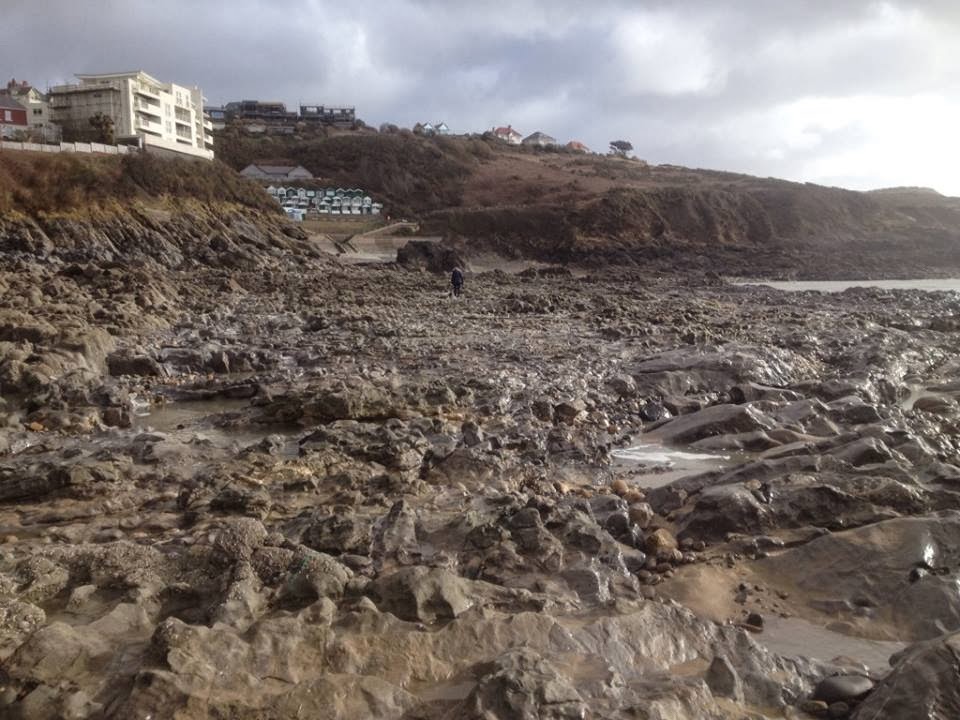 |
| Langland Beach, Gower, less the sand. M Crafer, Feb 2014. Most of the sand did come back in 2015, but not all of it. |
There were huge strandings of bivalves on The Gower. Local resident and ecologist, Mike Crafer, reported that at least one of the smaller beaches there had disappeared with almost 3m-depth of sand gone. See Patrick Barkham's 7 February column in The Guardian for more opinion on the future shape of Britain's coast.
Experience with both flooding and coastal erosion during the 1990s and to the present, further underline the need for the Government to kick off an honest debate with the public, not only about adaptation, but planning for a future when some vulnerable coastal and floodplain settlements, farmland and nature reserves, will not be able to survive as climate change impacts become more severe. Heritage and conservation bodies have much to lose; in some places they may not be able to gain new ground when long-established nature reserves lose out to either the sea or inland floods. The shape of Britain will change, and so will its wildlife.
No comments:
Post a Comment
Note: only a member of this blog may post a comment.